-
E-mail
2524300166@qq.com
-
Phone
18015580277
-
Address
No. 55 Dongfu Road, Suzhou Industrial Park
Product Categories
Suzhou Yucheng Instrument Co., Ltd
Caitu GPS measuring instrument
NegotiableUpdate on 04/04
- Model
- Nature of the Manufacturer
- Producers
- Product Category
- Place of Origin
Overview
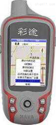
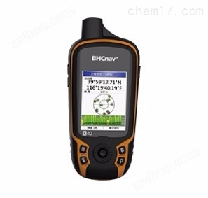
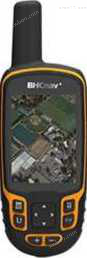
The Caitu GPS measuring instrument K82B adopts a GNSS chip design, which can support separate or combined positioning of Beidou, GPS, and GLONASS; *The design of the quadruple helix antenna ensures fast and reliable satellite positioning; An open map architecture with built-in national maps, supporting users to create their own vector maps, satellite images, and various raster maps; 2.83 "semi reflective and semi transparent color display screen, with a wide field of view, better resolution than similar products, and delicate images; Supports lithium battery and AA battery power supply, suitable for long-term outdoor work; The product features a three proof and sturdy design, allowing it to float on the water surface for safer use.
Product Details
Caitu GPS measuring instrumentK82BDesigned with GNSS chips, it can support separate or combined positioning of Beidou, GPS, and GLONASS; *The design of the quadruple helix antenna ensures fast and reliable satellite positioning; An open map architecture with built-in national maps, supporting users to create their own vector maps, satellite images, and various raster maps; 2.83 "semi reflective and semi transparent color display screen, with a wide field of view, better resolution than similar products, and delicate images; Supports lithium battery and AA battery power supply, suitable for long-term outdoor work; The product features a three proof and sturdy design, allowing it to float on the water surface for safer use.
Caitu GPS measuring instrumentK82BProduct Parameters
K82BHardware and Performance |
|
| size | 62*172*36mm |
| weight | 161g, 206g (including dry battery) 197g (including lithium battery) |
| screen size | 2.83 inches |
| Screen Type | Semi reflective and semi transparent color display screen |
| touch control | not supported |
| resolution | 240x320 |
| power supply method | Lithium battery+2 No. 5 batteries |
| battery life | 15 hours (lithium battery), 10 hours (No. 5 battery) |
| waterproof rating | IPx7 |
| float | √ |
| computer interface | USB 2.0 |
| GNSS performance | |
| Satellite system | GPS、BDS 、GLONASS, Support SBAS |
| Antenna type | Four arm spiral antenna |
| precision | <5m |
| Differential accuracy | <3m(SBAS) |
| update rate | 1Hz |
| Storage performance | |
| memory | RAM:128MB ROM:4GB |
| waypoint | 3000 pieces |
| route | 200 pieces/50 points |
| flight path | 400 pieces (5000 points/piece) |
| map | |
| base map | √ |
| National Detailed Map | √ |
| contour map | √ |
| Self made vector map | √ |
| Homemade grid map | √ |
| Features | |
| Point average | √ |
| coordinate system | WGS84、 Beijing 54, Xi'an 80 CGCS2000、 Custom Coordinate System |
| path planning | √ |
| Track measurement area | √ |
| Route measurement area | √ |
| Track profile diagram | √ |
| NMEA output | NMEA0183 |
| hardware function | |
| Barometric altimeter | √ |
| thermometer | √ |
| Electronic compass | √ |
| Gravity sensor | not supported |
| Expand storage card | Micro SD card, ******* 32GB |
| lithium battery | 1700mAh lithium battery |
| Wireless data transmission | not supported |
| camera | not supported |
| Image Viewing | not supported |