-
E-mail
2524300166@qq.com
-
Phone
18015580277
-
Address
No. 55 Dongfu Road, Suzhou Industrial Park
Product Categories
Suzhou Yucheng Instrument Co., Ltd
Caitu GPS measuring instrument
NegotiableUpdate on 04/04
- Model
- Nature of the Manufacturer
- Producers
- Product Category
- Place of Origin
Overview
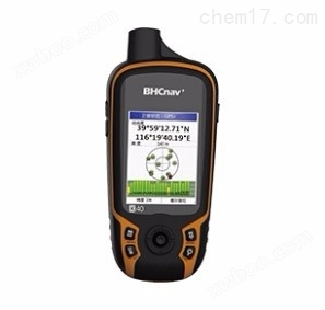
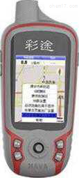
Caitu GPS measuring instrument adheres to the classic design of Caitu N series, compact and easy to carry; Support GPS and Beidou system, dual star positioning is fast and reliable; 2.2 "semi reflective and semi transparent color display screen, with better resolution than similar products and finer picture quality; The built-in dual battery system supports both lithium and AA batteries, making it suitable for long-term outdoor work; Adopting an open map software architecture, it can use vector maps, DEM contour maps, satellite maps, raster maps, and can also download offline maps for free online; Key operation, more reliable for use in outdoor environments.
Product Details
Caitu GPS measuring instrumentProduct Overview:
Caitu K62B is a handheld GPS/GIS data acquisition product developed for various professional work of industry users. The new series of products is easy to operate, flexible, and user-friendly, with stronger professionalism and more suitable for industry work needs. The new generation of high-sensitivity GPS+Beidou module can search for all visible satellites, quickly locate, and have more reliable accuracy. The SBAS differential accuracy can reach within 3 meters.
Caitu GPS measuring instrumentProduct Features:
72 channels, new generation high-sensitivity GPS+Beidou dual star system, faster and more accurate star search
2.2-inch imported industrial grade, high-definition color display screen, clearly visible under strong light
Standard Micro SD card slot for unlimited expansion of map data storage space
Lide's power management technology, ergonomic design for enhanced outdoor use time, one handed operation, long-term grip without fatigue
Imported CE fireproof material for the shell, more sturdy and environmentally friendly
Compatible with Google Earth user data, MG software (optional) allows customers to convert maps themselves
Standard ZUI upgraded national detailed drawings, customized vector and contour maps Can load national satellite image maps
The new version of the software has stronger practicality, more complete functions, and faster running speed
Technical Specifications:
GNSS |
physical properties |
||
通道 |
72通道 (L1,B1) |
size |
57mm×129mm×28mm |
定位精度 |
Single machine positioning: 3-5 meters(a)Real time differential: 1-3 meters (SBAS)(b) |
weight |
113g (excluding battery) |
positioning time |
Hot start<2 seconds Cold start<35 seconds |
Shell material | Industrial grade materials |
update rate |
1Hz |
waterproof rating | IPX7 |
antenna |
Satellite receiving antenna |
Operating Temperature | -20℃-+60℃ |
memory |
4GB |
Storage temperature | -30℃-+70℃ |
Navigation features |
fall | 1.5 meters (cement floor) | |
waypoint |
3000 pieces(c) |
Screen characteristics | |
flight path |
400 items |
type | Semi reflective and semi transparent color display screen |
route |
200 items |
size | 2.2″ |
map |
National Detailed Map |
resolution | 240×320 QVGA |
Road navigation |
support |
color | 65K color TFT |
User defined map |
support |
Power Characteristics | |
Features |
Battery Type | Li ion (1700mAh), 2 x AA batteries (not included) | |
Storage expansion |
Micro SD card, 32GB high (not included) |
Usage time | 5 hours (Li ion)(d), 10 hours (AA)(d) |
interface |
USB 2.0 |
Standard Configuration | Host, data cable, software CD, manual, certificate of conformity, warranty card, lanyard, packaging box, lithium battery, lithium battery charger |
transmission protocol |
NMEA0183 |
Optional accessories | Portable pouch, car power plug, car holder, inductive GPS antenna |
coordinate system |
WGS84、 Beijing 54, Xi'an 80 CGCS2000、 Customize Coordinate System |
|
|
Fishing and Hunting Information |
support |
|
|
Daily and Monthly Information |
support |
|
|
area measurement |
Real time recording mode, route mode, save track mode, shutdown memory, nested pause |
|
|
| sensor | Three axis electronic compass, barometric altimeter, G-Sensor, thermometer | ||