-
E-mail
2524300166@qq.com
-
Phone
18015580277
-
Address
No. 55 Dongfu Road, Suzhou Industrial Park
Product Categories
Suzhou Yucheng Instrument Co., Ltd
Caitu GPS measuring instrument
NegotiableUpdate on 04/04
- Model
- Nature of the Manufacturer
- Producers
- Product Category
- Place of Origin
Overview
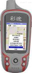
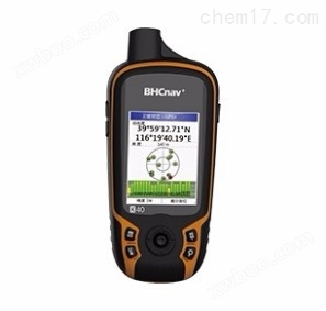
Caitu GPS measuring instrument adheres to the classic design of Caitu N series, compact and easy to carry; Support GPS and Beidou system, dual star positioning is fast and reliable; 2.2 "semi reflective and semi transparent color display screen, with better resolution than similar products and finer picture quality; The built-in dual battery system supports both lithium and AA batteries, making it suitable for long-term outdoor work; Adopting an open map software architecture, it can use vector maps, DEM contour maps, satellite maps, raster maps, and can also download offline maps for free online; Key operation, more reliable for use in outdoor environments.
Product Details
Caitu GPS measuring instrumentBasic Information
| brand | Caitu | model | K40 |
| GPS定位精度 | 3-5 meters | alarm method | Power failure alarm |
| Map function | have | Battery Type | Dry battery (lithium battery optional) |
| Battery usage time | 15 hours | waterproof function | have |
| resolution | 240x320 | interface text | Chinese |
| type | handheld | Area calculation function | have |
| memory | other | Antenna type | Built in patch antenna |
| External power supply form | USB | Coordinate dual display function | have |
| Caitu GPS measuring instrumentHardware and Performance | |
|---|---|
| size | 57X129X28mm |
| weight | 110g (excluding battery) |
| screen size | 2.2 inches |
| Screen Type | Industrial grade 260000 color TFTLCD |
| touch control | not supported |
| resolution | 240x320 |
| power supply method | 2AA+Li |
| battery life | Two No. 5 batteries for about 15 hours, lithium batteries for 25 hours, 10 hours (AA) |
| waterproof rating | IPx7 |
| float | × |
| computer interface | USB 2.0 |
| GNSS performance | |
|---|---|
| system | GPS+GLONASS |
| type | High sensitivity omnidirectional |
| precision | Single machine positioning<5m |
| Differential accuracy | Differential positioning<3m |
| update rate | 1Hz |
| Storage performance | |
|---|---|
| memory | 4GB RAM on the body |
| waypoint | 3000 pieces |
| route | 200 pieces (200 pieces/100 points) |
| flight path | 400 pieces (5000 points/piece) |
| map | |
|---|---|
| base map | not supported |
| National Detailed Map | √ |
| contour map | Support user customization |
| Self made vector map | not supported |
| Homemade grid map | √ |
| Features | |
|---|---|
| Point average | √ |
| coordinate system | WGS84、 Beijing 54, Xi'an 80 CGCS2000、 Custom Coordinate System |
| path planning | not supported |
| Track measurement area | √ |
| Route measurement area | √ |
| Measurement of agricultural machinery area | not supported |
| Slope area measurement | not supported |
| Regular area measurement | not supported |
| Track profile diagram | not supported |
| NMEA output | NMEA0183 (Transmission Protocol) |
| hardware function | |
|---|---|
| Barometric altimeter | √ |
| thermometer | √ |
| Electronic compass | √ |
| Gravity sensor | √ |
| Expand storage card | Micro SD card, 32GB (not included) |
| lithium battery | Li-ion(1700mah) |
| Wireless data transmission | not supported |
| camera | not supported |
| Image Viewing | not supported |