-
E-mail
sales@eco-tech.com.cn
-
Phone
18210150760
-
Address
101B, Unit 1, Building 6, Courtyard 3, Gaolizhang Road, Haidian District, Beijing
Product Categories
Beijing Yiketai Ecological Technology Co., Ltd

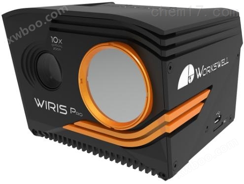
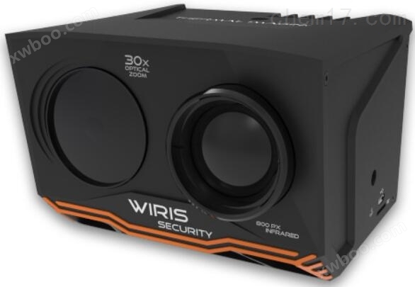
WIRIS-S High Definition Visible and Infrared Thermal Imager
NegotiableUpdate on 04/28
- Model
- Nature of the Manufacturer
- Producers
- Product Category
- Place of Origin
Overview
WIRIS-S high-definition visible light and infrared thermal imaging camera, as a multi-purpose air land dual base visible light and infrared thermal imaging binocular camera, has 800 #215; 600 pixel ultra-high infrared resolution, excellent temperature sensitivity, and sturdy and durable aluminum body. At the same time, it also integrates a high-performance visible light lens with 30x optical zoom, which has high sensitivity to dusk and dawn vision. Even in low light conditions of 0.0008lux, RGB images are clear and distinguishable, and it has high penetration ability for haze.
Product Details
In recent years, the emergence of infrared thermal imaging technology has added night vision and perspective functions to traditional visible light monitoring in low light and nighttime environments. It plays a crucial role in applications such as online ecological environment monitoring, forest fire prevention, wildlife protection, industrial security, fire rescue, and large-scale on-site monitoring.

WIRIS-S High Definition Visible and Infrared Thermal ImagerAs a versatile air land dual base visible light and infrared thermal imaging binocular camera, it has an 800 × 600 pixel ultra-high infrared resolution, excellent temperature sensitivity, and a sturdy and durable aluminum body. simultaneouslyWIRIS-S High Definition Visible and Infrared Thermal ImagerIt also integrates a high-performance visible light lens, 30Triple optical zoom has high sensitivity to the visual effects of dusk and dawn. Even in low light conditions of 0.0008lux, RGB images are clear and distinguishable, and it has a high ability to penetrate haze.

Beijing Yiketai Ecological Technology Company, with its rich experience in ecological environment, forest resource management, animal behavior monitoring research and application, combined with its independently developed EcoDrone drone and near earth remote sensing platform, has introduced visible light imaging and infrared thermal imaging sensor technology to solve the application defects of traditional monitoring methods in multi-dimensional, large-scale, night vision, concealed environments, and environments invisible to the human eyeforNature reserve management, wildlife investigation, forest fire prevention, security monitoring, on-site emergency monitoring investigation, field investigation, large-scale on-site monitoring, fire rescue, etcThe field provides a foundation based onEcoDrone drone remote sensing platformandOn site monitoring of large-scale near ground scenesThe * solution.

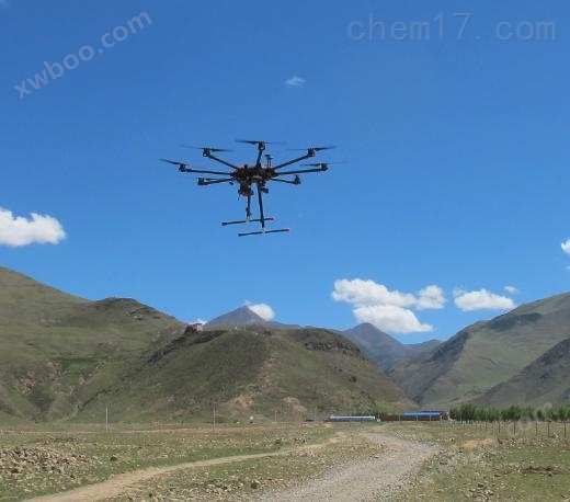
EcoDrone UAS-4/8 UAV Remote Sensing Platform
1、 Product advantages
- Air land dual base, flexible configuration and selection
- Visible light thermal infrared dual lens imaging system, synchronously acquiring visible light and infrared thermal imaging data
- Compared to EcoDrone UAS-4 or UAS-8The drone platform forms a ready to fly system
- Support multiple peripheral interfaces, compatible with multiple models of unmanned aerial vehicle systems such as DJI M600
- 800 × 600 high-resolution, high-sensitivity infrared thermal imaging lens
- Multi mode view function: full screen, main view swap, picture in picture, synchronous zoom function
- 256GB high-speed SSD provides data storage guarantee for long-term continuous monitoring
- Reserve custom development applications to meet user functional expansion needs
- Durable and elegant structure, designed specifically for harsh outdoor conditions
- Non ITAR products, unrestricted import and export
2、 RGB lens functional advantages
- 30x optical zoom, clear imaging from a distance of several kilometers away

- Synchronize scaling and picture in picture display to enhance contrast and highlight differences in details

- Switching between primary and secondary perspectives, which can be adjusted in real-time according to different user needs

- Vibration compensation eliminates jitter caused by optical zoom, resulting in stable 30x imaging during full speed flight

- Automatic white balance, WDR, Infrared cutting filtering, defogging, and 3D noise reduction functions
3、 Technical parameters
Thermal camera specifications | |
Infrared image resolution |
800 × 600 pixels |
temperature range |
-20 ℃ to+150 ℃ |
Temperature sensitivity |
0.04℃(40mK) |
frame rate |
25Hz or 9Hz |
Spectral Range/Detector |
7.5-13.5 μ m/uncooled VOx micro radiation detector |
digital zoom |
1-12 times continuous |
Digital visible light camera | |
resolution |
1920 × 1080 pixels (full HD image quality), 1/2.8 "back illuminated CMOS sensor |
optical zoom |
30x optical zoom with shock absorption compensation and image stabilization functions |
Low illumination |
0.0008lux (ICR on, 1/4s slow shutter, high sensitivity on) |
Field of view/focal length |
Ultra zoom 2.3 ° - Ultra wide 63.7 °, focal length 129.0mm-4.3mm |
image enhancement |
Automatic white balance, WDR, Infrared cutting filtering, defogging, 3D noise reduction |
Storage and Data Recording | |
storage |
Built in 128GB or 256GB high-speed SSD for storing images and video recordings The external card slot is for micro SD card and USB flash drive, used for storing images |
Camera function |
Color palette:19 adjustable color palettes for different flight conditions Multi camera mode:Full screen mode, infrared only mode, visible light only mode, picture in picture mode Shooting cycle:More than 1 second, infrared and visible light synchronized DDE function:Digital detail enhancement for high dynamic range imaging NUC Control Settings: Automatic or manual |
Power&Weight | |
input voltage |
9-36V DC, Coaxial 2.1 × 5.5mm, shell GND, 19W |
weight |
<780g, Durable aluminum body and ABS components |
4、 Application Fields
- Unmanned aerial vehicle remote sensing system: Combined with EcoDrone UAS-4, UAS-8, or DJI M600 unmanned aerial vehicle platforms, the Ready to fly unmanned aerial vehicle remote sensing technology solution is applied in nature reserve management, wildlife investigation, forest fire prevention, security, on-site emergency monitoring and investigation, etc.
- Ground monitoring system: connected with ground monitoring terminal network to form a land-based large-scale scene on-site monitoring solution, applied to large-scale scene on-site monitoring, ranch monitoring, wildlife monitoring, industrial security, fire rescue, etc.
- Independent use, portable monitoring solution, applied in field investigations, industrial security, and online monitoring fields.
Similar Product Recommend