-
E-mail
sales@eco-tech.com.cn
-
Phone
18210150760
-
Address
101B, Unit 1, Building 6, Courtyard 3, Gaolizhang Road, Haidian District, Beijing
Product Categories
Beijing Yiketai Ecological Technology Co., Ltd
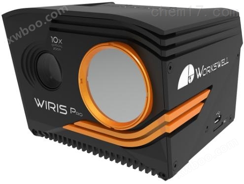
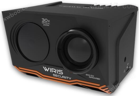
WIRIS Pro Infrared Thermal Imaging Camera
NegotiableUpdate on 04/28
- Model
- Nature of the Manufacturer
- Producers
- Product Category
- Place of Origin
Overview
The WIRIS Pro infrared thermal imaging camera is a universal land air dual base infrared thermal imaging camera newly launched by Workswell. Specially designed for use in demanding environments such as precision agriculture, environmental monitoring, industrial automation, archaeological research, and other fields. It is currently one of the most advanced professional infrared thermal imaging cameras used in the above-mentioned application fields in the world.
Product Details
WIRIS Pro Infrared Thermal Imaging CameraIt is a universal land air dual base infrared thermal imaging camera newly launched by Workswell company. Specially designed for harsh environments such as precision agriculture, environmental monitoring, industrial automation, archaeological research, and more. It is currently one of the most advanced professional infrared thermal imaging cameras used in the above-mentioned application fields in the world.

WIRIS Pro Infrared Thermal Imaging CameraAs a professional temperature detection camera, WIRIS Pro is equipped with a 640 × 512 pixel LWIR micro radiation detector and has a super-resolution mode function, which can provide a super infrared resolution of 1280 × 1024 pixels through software calculation. In addition, the RGB lens has full HD image quality (1920 × 1080 pixels) resolution, and importantly, it provides optical zoom function with up to 10x zoom (i.e. 6.9 ° to 58.2 ° field of view), making long-distance imaging clear and distinguishable.
1、 Product advantages
l **Data storage options:
WIRIS Pro, as one of the UAV cameras, is equipped with a built-in SSD with a capacity of 128GB or 256GB. In addition, data can be stored on an external USB flash drive or microSD card. Three options ensure that data is never lost.
lRobust and elegant structural design:
To adapt to industrial and outdoor environments and avoid potential risks of camera damage. The WIRIS Pro is protected by a sturdy casing made of lightweight aluminum alloy. In addition, its sensitive thermal camera lens is protected by a replaceable protective cover made of germanium.
lAccurate measurement design:
Scientific research and industrial applications require very precise measurements in most cases, and each thermal camera of WIRIS Pro is individually manufactured and precisely calibrated. The calibration certificate is included at the final factory.
lWIRIS OS operating system:
Like other WIRIS series cameras, the WIRIS Pro is equipped with the WIRIS OS operating system, which has many features that can be used for security and search and rescue applications, maximizing the functionality and characteristics of these two cameras, and providing many measurement functions that other brand products do not have.
ldevelopmentcustomizeapplication:
WIRIS Pro provides customers with an SDK toolkit for developing custom applications (suitable for MATLAB development environment). The SDK allows access to underlying functionalities and enables developers to fully unleash the potential of the WIRIS Pro camera hardware.
lLarge scale interconnectivity features:
WIRIS Pro provides various interfaces such as S.BUS, CAN bus, Ethernet, Mavlink, GPS, external triggers, etc., which can be widely connected to drones, control units, external GPS sensors, etc. Wi Fi low latency real-time video stream image stream transmission.
2、 Technical parameters
Main features of WIRIS Pro | |
Super resolution mode |
WIRIS Pro adopts super-resolution mode, which can obtain 1.3M infrared images in one shot. |
Onboard operating system |
WIRIS operating system, used for real-time data stream transmission and control during flight ——Ensure that all camera functions are available ——Easy to control through S.Bus, CAN bus, MavLink, RJ-45 or trigger |
10x optical shock absorption zoom |
Full HD image quality 10x optical zoom camera with shock compensation function |
Thermal camera specifications | |
Infrared image resolution |
640 × 512 pixels |
Infrared super-resolution mode |
1280 × 1024 pixels (native resolution can be increased to 1.3Mpx) |
FPA sensor size |
1.088×0.8705cm |
temperature range |
-25 ℃ to+150 ℃, -40 ℃ to+550 ℃ Optional temperature range: 50 ℃ to 1000 ℃, 400 ℃ to 1500 ℃ |
Temperature sensitivity |
Standard 0.05 ℃ (50mK), optional 0.03 ℃ (30mK) |
precision |
± 2% or ± 2 ℃ |
frame rate |
30Hz or 9Hz |
Spectral Range/Detector |
7.5-13.5 μ m/uncooled VOx micro radiation detector |
Lens calibration |
The packaging contains a calibration certificate |
Optional lenses |
18 °, 32 °, 45 °, 69 ° (interchangeable lenses, all calibrated) |
Lens protection filter |
Filters protect the lens from external damage during flight |
digital zoom |
1-14 times continuous |
Digital visible light camera | |
resolution |
1920 × 1080 pixels (full HD image quality), 1/3 "sensor, automatic white balance, wide dynamic range, backlight compensation, exposure and gamma control |
optical zoom |
10x optical shock absorption zoom |
field of view |
Ultra zoom 6.9 ° - ultra wide 58.2 °, focal length 33.0mm-3.3mm |
noise reduction |
Special 3D noise reduction function |
focus |
Auto focus and direct zoom synchronization |
Storage and Data Recording | |
storage |
Built in 128GB or 256GB high-speed SSD for storing images and video recordings The external card slot is for micro SD card and USB flash drive, used for storing images |
Image and video formats |
Radiant JPEG and Full HD Digital JPEG Images Radiation TIFF images (compatible with Pix4D and Agisoft) H.264 encoded high-definition video for digital cameras Full frame infrared radiation video (raw data recorded at 30Hz) |
GPS geotags (images and videos) |
MavLink or external GPS or compatible DJI A3 controller (connected via CAN bus) |
Interface&Real time Remote Control | |
10 pin digital port |
S.BUS、CAN bus、MavLink、 External GPS connection, external trigger |
Ethernet (RJ-45) port |
SDK for developing and RTSP video streaming and camera control |
Micro USB 2.0 port |
High-capacity storage Camera control and video streaming (can only be selected according to needs) |
USB 2.0 port |
Connecting keyboard for indoor WIRIS camera control |
Remote control system |
WIRIS OS ensures real-time control of all camera functions during flight |
Remote control options |
S. BUS protocol CAN bus is used for real-time control and GPS geotagging of DJI M600 RJ-45 is used for wireless uplink installation (video streaming and camera control) |
Camera function |
Measurement function:Hot/cold spot detection, center point measurement Temperature range setting:Automatic, manual or span mode Advanced warning mode:Above,below,between,above & below Multi camera mode:Full screen mode, infrared only mode, visible light only mode, picture in picture mode Shooting cycle:More than 1 second, infrared and visible light synchronized Temperature unit:Celsius, Fahrenheit, Kelvin Measurement calibration:Radiation rate, reflection/atmospheric temperature, humidity NUC Control Settings: Automatic, manual, timed or triggered by the operator |
Micro HDMI video output |
1280 × 720 pixels (720p), aspect ratio 16:9, mini HDMI video output |
Software&SDK | |
desktop software |
Thermal imaging analysis and reporting software compatible with Windows and MAC OS |
SDK |
Workswell SDK for MATLAB development |
Power supply, weight&size | |
input voltage |
9-36V DC, Coaxial 2 × 6.4mm, shell GND |
average power consumption |
12W |
weight |
<450g |
Dimensions (length x width x height) |
83mm×85mm×68mm |
install |
2 × 1/4-20UNC screw holes (1 at the bottom and 1 at the top) |
Shell material |
Durable aluminum body with stable and reliable measurement |
environmental parameters | |
Operating Temperature |
-20 ℃ to+55 ℃ |
Storage temperature |
-30 ℃ to+60 ℃ |
3、 Application Fields
Analysis of vegetation drought stress
Soil moisture monitoring and conservation
Precision agriculture, smart agriculture
Forest fire risk monitoring
Marine Science Research
Animal behavior monitoring
Electricity and photovoltaic inspection
security surveillance
search and rescue
landfill

Similar Product Recommend