-
E-mail
sales@eco-tech.com.cn
-
Phone
18210150760
-
Address
101B, Unit 1, Building 6, Courtyard 3, Gaolizhang Road, Haidian District, Beijing
Product Categories
Beijing Yiketai Ecological Technology Co., Ltd
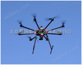
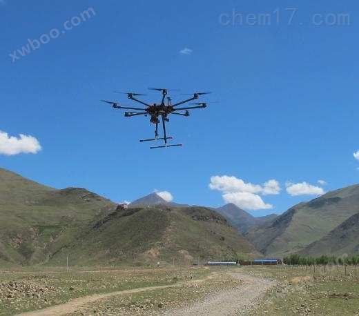
EcoDrone lightweight airborne LiDAR system
NegotiableUpdate on 04/28
- Model
- Nature of the Manufacturer
- Producers
- Product Category
- Place of Origin
Overview
The Yiketai lightweight airborne LiDAR system is a new generation of airborne LiDAR system developed independently by our company based on the EcoDrone multi rotor UAV remote sensing system, equipped with foreign * LiDAR sensors, and independently integrated, revolutionizing the airborne scanning mode of LiDAR. Compared to traditional airborne LiDAR, which often weighs hundreds of kilograms, has a price tag of tens of millions of yuan, complex operations, and high transportation and logistics costs, this product has advantages such as small size, light weight, low cost, strong adaptability, and easy operation. To meet the different needs of customers for price, product functionality, required accuracy, and other indicators,
Product Details
EcoDroneLight and small airborne LiDAR system
The Yiketai lightweight airborne LiDAR system is a new generation of airborne LiDAR system developed independently by our company based on the EcoDrone multi rotor UAV remote sensing system, equipped with foreign * LiDAR sensors, and independently integrated, revolutionizing the airborne scanning mode of LiDAR. Compared to traditional airborne LiDAR, which often weighs hundreds of kilograms, has a price tag of tens of millions of yuan, complex operations, and high transportation and logistics costs, this product has advantages such as small size, light weight, low cost, strong adaptability, and easy operation.
To meet the different needs of customers for price, product functionality, required accuracy and other indicators, our company offers two optional solutions, namely the SCOUT solution for unmanned aerial vehicle LiDAR based on Velodyne Puck Lite sensor and the miniRANGER solution for unmanned aerial vehicle LiDAR based on Riegl miniVUX sensor.

Main technical indicators
1TheEcoDrone UAS-8drone platform
1)Machine weight ≤ 5000g, maximum takeoff weight ≥ 15000g, maximum load ≥ 5000g, symmetrical wheelbase 1200mm, automatic folding tripod, screw motor, shock absorption without virtual position
2)Has strong scalability, can flexibly install and configure multispectral, hyperspectral, infrared thermal imaging LiDAR、 Various sensors such as visible light can be installed simultaneously to simultaneously collect diverse ground information
3)The idle hover time shall not be less than 50 minutes, the effective operation time shall be 30 minutes (equipped with a multispectral camera), and the flight speed shall be 10m/s
4)High precision GPS positioning module, supporting GPS/Beidou dual-mode
5)Equipped with flight modes such as waypoint navigation, fixed point, hover, fixed altitude, route, area coverage, surround and follow (follow me mode, ground station support required), and a "black box" function module
6)Equipped with signal interference protection, fault protection, low voltage automatic protection, and one click automatic return and landing function
7)Pressure and GPS altitude determination, ultrasonic altitude determination within 10m, accuracy of 1cm
8)Equipped with a 4K high-definition color imaging lens as standard, with a frame rate of 30FPS (maximum 4K resolution) and a picture resolution of 16MP; optical lens f/2.8120 degree HFOV (optional 82 degree HFOV distortion free optical lens); Optional DSLR 20MP or 24MP resolution color lens
9)Remote control: Operating frequency 2.400-2.483GHz (DSSS technology), optional channel number 16 or 32, transmission power (EIRP) FCC 100 dBm, control distance 2.7km(Open the extended range mode for approximately 5 kilometers)
10)Online Image Transmission (FPV Reception): Dual channel image transmission technology for analog and digital signals, capable of simultaneously transmitting visible light and thermal imaging videos online, operating in a frequency band of 5.8G, supporting 1080P real-time high-definition image transmission, with a display screen resolution of 1920x1080 and a maximum distance of 5km. It ensures synchronous image transmission without delay or delay, and can also receive high-definition display images online
11)Data simultaneous interpreting module, including the synchronous transmission and display of position (longitude and latitude), height, temperature, humidity, solar radiation, ground temperature, solar radiation and other data information during UAV operation on the ground station
12)Ground station: including portable case, field survey grade notebook and corresponding software, capable of switching between Google Maps, Amap or Bing Maps, automatic flight planning for waypoint input, monitoring of speed/distance/altitude/horizontal/longitude/latitude/ascent/descent speed/temperature, downloading task log files, realizing unmanned aerial vehicle automatic tracking ground station function (follow me), etc
13)Energy Management System: Standard battery capacity of 22000mAh, maximum charging current of 12A, dual channel charger, maximum charging power of 1400W
2.1TheSCOUTLidar remote sensing solution
1)Dimensions: 160 × 116 × 116mm
Working voltage: 12-28V
Power consumption: 40W
Weight: 1.65Kg
Working temperature: -10 ℃~40 ℃
2)navigation system
Satellite systems: GPS, GLONASS
Calibration support: static, differential, dual antenna
Working mode: real-time, post-processing
Positioning accuracy: 1cm+1ppm (horizontal direction)
3)LiDARsensor
Laser performance: Level 1 eye safety, 905nm
Measurement range: 1m~120m, resolution: 2mm
Distance measurement error: 30mm
Scanning frequency: 300000 times/second, with a maximum of 600000 points/second
Field of view: Vertical±15°, 360 degrees horizontally
Multiple echoes: 2
Number of laser panels: 16
*Scanning height: 20-60m (ground clearance)
The relationship between point cloud density and flight speed and altitude
2.2TheTHE mini RANGERLidar remote sensing solution
1)Sensor dimensions: 269 × 99 × 85mm (STIM)/302 × 99 × 85mm (FOG)
Navigation box dimensions: 300 × 99 × 85mm
Working voltage: 12-28V
Power consumption: 80W
Weight (sensor+cable): 3.5Kg (7.7lbs) FOG/IMU; 2.9Kg(6.4lb)STIM/IMU
Working temperature: -10 ℃~40 ℃
2)navigation system
Satellite systems: GPS, GLONASS
Calibration support: static, differential, dual antenna
Working mode: real-time, post-processing
Positioning accuracy: 1cm+1ppm (horizontal direction)
3)LiDARsensor
Laser performance: Level 1 eye safety, 905nm
Zui small distance measurement: 3m
Laser beam size: 160mm × 50mm@100m
Maximum effective measurement frequency: 100000 times/second
Field of view angle: 360 °
精度: 15mm@150m
4)Scanner performance
Scanning mechanism: mirror rotation
Mirror rotation speed: 10-100 scans per second
Scanning angle width: 0.05 ° to 0.5 °
Angle measurement resolution: 0.001 °
Internal synchronous timer:Real time synchronization timestamp
The relationship between point cloud density and flight speed and altitude (100kHz)
3、Standard 4K high-definition RGB color imaging lens, F/2.8, FOV 120 degree wide-angle lens (optional with other optical lenses), image resolution 16MP; optional with Sony A6000 lens
4Software: LiDAR point cloud data processing, 3D vector data and models, etc
technical route


Figure 3 Topographic Mapping

Figure 5 Cross section thickness of point cloud
Accuracy verification:
Randomly select several feature points in the survey area as control points, use RTK method to measure the coordinates of the control points, compare the laser point cloud measurement coordinates with the measured coordinates of the control points, and obtain the true elevation error, reflecting its accuracy index.
Control point: plane accuracy<1cm; elevation accuracy<1.5cm
serial number |
easting |
North coordinate |
Control point elevation |
Laser point elevation |
High range true error |
1 |
355007.194 |
6681305.610 |
65.159 |
65.168 |
+0.009 |
2 |
355042.113 |
6681331.238 |
68.236 |
68.279 |
+0.043 |
3 |
355054.820 |
6681319.338 |
68.628 |
68.667 |
+0.039 |
4 |
355071.565 |
6681286.798 |
66.806 |
66.844 |
+0.038 |
15 |
354970.664 |
6681080.558 |
71.597 |
71.558 |
-0.039 |
43 |
355124.750 |
6681082.099 |
67.006 |
67.006 |
-0.000 |
44 |
355132.507 |
6681054.538 |
67.092 |
67.034 |
-0.058 |
45 |
355075.257 |
6681018.545 |
66.014 |
66.045 |
+0.031 |
47 |
355038.927 |
6681041.354 |
67.626 |
67.601 |
-0.025 |
|
The smallest error The biggest error mean error root mean square standard deviation |
-0.058 +0.043 0.031 0.035 0.037 |
||||
As shown in the table above, the mean square error (standard deviation) of the point elevation is 3.7cm, which meets the requirements of high-precision surveying. Can be used in various fields, including large-scale topographic mapping.
3、 Application direction
Drone LiDAR combines the advantages of both drones and LiDAR, and is widely used in various industries due to its low cost, high precision, and efficient convenience. Typical applications are as follows:
ltopographic surveying
lUrban 3D modeling
lAgriculture and Forestry
lArchaeological and cultural heritage protection
lGlacier and Snow Mapping
lLandslide monitoring
Similar Product Recommend