-
E-mail
sales@eco-tech.com.cn
-
Phone
18210150760
-
Address
101B, Unit 1, Building 6, Courtyard 3, Gaolizhang Road, Haidian District, Beijing
Product Categories
Beijing Yiketai Ecological Technology Co., Ltd


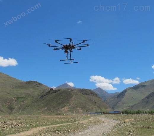
EcoDrone UAS-8 Multi functional Unmanned Aerial Vehicle Remote Sensing System
NegotiableUpdate on 04/28
- Model
- Nature of the Manufacturer
- Producers
- Product Category
- Place of Origin
Overview
The EcoDrone UAS-8 multifunctional unmanned aerial vehicle remote sensing system is a professional remote sensing measurement system developed and integrated by Yiketai Ecological Technology Co., Ltd. based on its independently developed professional level unmanned aerial vehicle system, using very advanced spectral imaging sensor technology, focusing on agriculture, forestry, and ecological environment monitoring fields.
Product Details
EcoDrone UAS-8 Multi functional Unmanned Aerial Vehicle Remote Sensing SystemIt is a professional remote sensing measurement system developed by Yiketai Ecological Technology Co., Ltd. based on its independently developed professional grade UAS unmanned aerial vehicle system, using very advanced spectral imaging sensor technology to focus on agriculture, forestry, and ecological environment monitoring.EcoDrone UAS-8 Multi functional Unmanned Aerial Vehicle Remote Sensing SystemThe main technical features are as follows:

- Independently developed 8-rotor professional unmanned aerial vehicle platform, with vertical takeoff and landing, one click return, high-precision GPS positioning, remote control online image transmission, and ground station online monitoring.
- Modular design, powerful scalability and compatibility, can be equipped with two different monitoring devices simultaneously, can freely replace monitoring devices, and meet various field monitoring requirements.
- Optional RGB lens, multispectral lens, hyperspectral lens, 3D LiDAR sensor, NDVI professional lens, infrared thermal imaging lens, air quality monitoring system, etc.
- Expert support, including drone experts, remote sensing experts, ecological environment experts, etc.
- Cooperative drone remote sensing joint training, can participate in advanced drone remote sensing training in Europe.

1 Technical parameters
(1) Drone platform
- Number of motors: 8 brushless motors
- Symmetrical motor wheelbase: 1200mm
- Empty weight: 5000g (excluding battery)
- Large takeoff weight: 16000g
- Payload: 6000g
- Dimensions: 1632mm × 1632mm × 650mm (propeller and GPS bracket both unfolded) 400mm × 400mm × 550mm (arm, propeller, GPS bracket folded)
- Transportation dimensions: 650mm × 650mm × 700mm
(2) Power system
- Large hover time: 50min (no load), 40min (load multispectral imaging)
- Hovering accuracy (GPS mode) better than: vertical: ± 0.2m; horizontal: ± 0.5m
- Large pitch angle: 25 °
- Large rotation angular velocity: pitch axis: 300 °/s, heading axis: 150 °/s.
- Large lifting and lowering speeds: 5m/s, 3m/s
- Capable of withstanding wind speeds of 10m/s (safe flight in level 5 winds) and 13m/s (level 6 winds) in an instant
- High altitude flight: ≥ 5000m
- Wind resistance: Level 6 (11m/s, 40km/h)
- Rain resistance ability: Can perform work tasks in light rain weather, but not in rainy weather
(3) Battery system
- Capacity: 22000mAh
- Voltage: 22.8V
- Energy: 501.6 Wh
- Overall weight of battery: approximately 2330g
- Rated power: Dual 1400W
(4) Flight Control System
- Model: Adopting an open-source framework and integrating autonomous dual machine hot backup flight control.
- Remote control operating frequency: 840MHz
- Communication distance (interference free, unobstructed): ≥ 15km
- Equivalent Omnidirectional Radiated Power (EIRP): 10dBm@900M The 13dBm@5.8G The 20dBm@2.4G
- Video output interfaces: HDMI, SDI, USB
- Collaborative function: supports multi machine interconnection
- *Working environment temperature: -10 ℃ to 40 ℃
- Ground station (laptop user provided): a one-stop intelligent software system with flight monitoring, parameter setting, voice reading functions, embedded terrain and landform data, fully automatic route planning, and support for one click return
2 Sensor Configuration
(1) Color imagingStandard configuration: 4k high-definition RGB lens with frame rate of 30FPS (under high resolution 4K), 2.7k resolution frame rate of 50FPS, image resolution of 12MP (4000x3000 pixels), pitch angle of -160 to+160 °, motion tracking accuracy of ± 0.1 °, optical lens f/2.8, 35mm equivalent focal length of 22.6mm, 82 degree HFOV, distortion free, and a mass of 88g.

(2) Multispectral imaging(Optional): Blue, green, red, red edge, near-infrared five band (5 channels) multispectral imaging, per pixel 8cm@120m Height, image acquisition rate of once per second for all 5 bands, 12 bit RAW, viewing angle of 47.2 °, SD card storage for multispectral images with geotags, brand new aluminum body, more durable and heat-resistant, weight of 232g. Optional 10 channel multispectral imaging system can be used to monitor shallow water environments (aerosols, aerosols, etc.) using newly added channels, and analyze chlorophyll efficiency or red edge slope in detail. The two camera bands can be used interchangeably, allowing users to create multiple new index models and conduct detailed analysis. Can be used with EcoDrone ® The UAS-4/8 drone platform forms a ready to fly system.

(3) Hyperspectral imaging(Optional): VIS-NIR hyperspectral imaging integrated solution for light and small unmanned aerial vehicle platforms, the entire system includes VNIR/NIR band hyperspectral imaging instrument, micro DPU, high-precision GNSS/IMU unit, fully automatic data acquisition according to task planning, MROI function, 224 band can be freely selected to meet different application needs of users, spectral sampling up to 2.68nm, system total weight is only 2.1 kilograms (2.4 kilograms for NIR band), and can be combined with EcoDrone ® Drones form a Ready to fly system, which can be equipped with or without a gimbal.

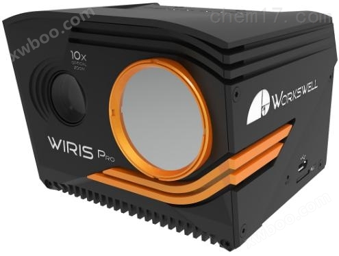
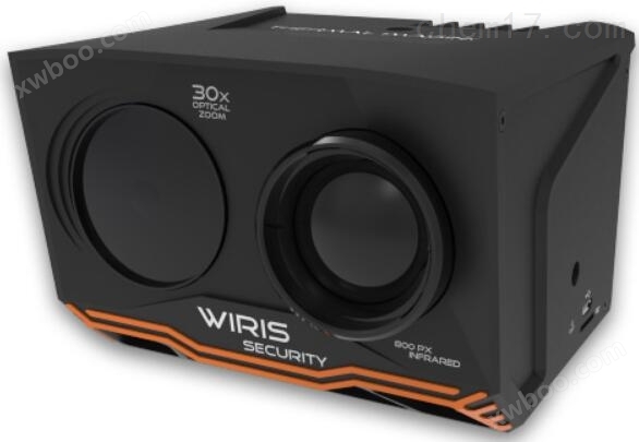
(4) Infrared thermography(Optional): Band 7.5-13.5 μ m resolution 640 × 512, sensitivity 30mK (0.03 ℃), 1-14x digital zoom, sensor calibrated with calibration certificate, real-time temperature measurement and analysis, temperature measurement range -25 ℃ -150 ℃; Built in 10x optical zoom lens, resolution 1920 × 1080; 19 color palettes available for online measurement. OptionalAgro Crop Water Stress Imaging Measurement Camera(CWSI, BCI online measurement)WIRIS-S security monitoring infrared thermal imaging camera(30 with optical zoom and low light night vision function)

(5) Smoke and gas imaging(Optional): Cooling InSb FPA detector (MWIR), thermal image resolution: 320 × 240 pixels; Band range: 3.2-3.4 μ m; Sensitivity: 0.015 ℃ (15mK); Image recording: radiation JPEG, radiation TIFF, visible light JPEG; Video recording: Radiated full frame infrared video, 30Hz, built-in RGB camera, resolution 1920 x 1080, 10x optical zoom, shock absorption compensation.

(6) Air quality monitoring module(Optional): EcoDrone products can measure various environmental pollution indicators online, including air temperature and humidity CO2、PM2.5/10、VOC、 Formaldehyde concentration, light intensity, GPS coordinates, timestamp, etc.

Attachment: Collection of Application Cases

Similar Product Recommend