-
E-mail
sales@eco-tech.com.cn
-
Phone
18210150760
-
Address
101B, Unit 1, Building 6, Courtyard 3, Gaolizhang Road, Haidian District, Beijing
Product Categories
Beijing Yiketai Ecological Technology Co., Ltd


EcoDrone Isa UAV Hyperspectral Remote Sensing System
NegotiableUpdate on 04/28
- Model
- Nature of the Manufacturer
- Producers
- Product Category
- Place of Origin
Overview
The EcoDrone Aisa UAV Hyperspectral Remote Sensing System is a professional remote sensing measurement system developed by Yiketai Ecological Technology Co., Ltd. on the basis of the original UAS-8 technology and practice, independently designed and developed by Yiketai Ecological Technology Co., Ltd. It is another heavy-duty, high endurance, professional grade UAS UAV system. It adopts * hyperspectral imaging sensor technology and integrates it into the field of agriculture, forestry, and ecological environment monitoring.
Product Details
EcoDrone Isa UAV Hyperspectral Remote Sensing SystemYiketai Ecological Technology Co., Ltd. has independently designed and developed another heavy-duty, high endurance, professional grade UAS unmanned aerial vehicle system based on the original UAS-8 technology and practice. It adopts *'s hyperspectral imaging sensor technology to develop an integrated professional remote sensing measurement system focused on agriculture, forestry, and ecological environment monitoring.EcoDrone-AisaUnmanned Aerial Vehicle Hyperspectral Remote Sensing SystemThe main technical features are as follows:

EcoDrone drone hyperspectral remote sensing technology
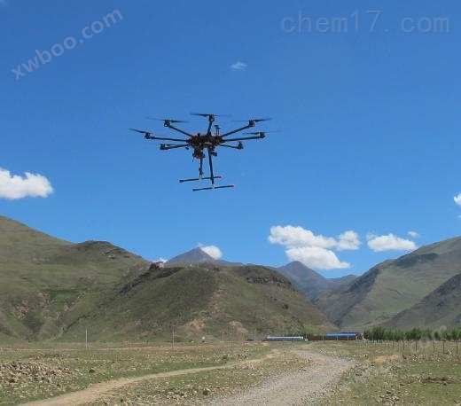
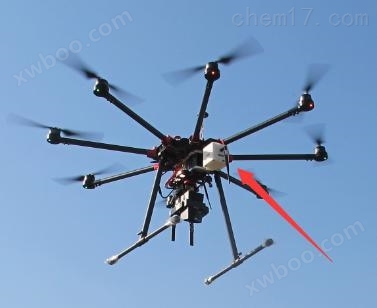
1.1 Unmanned Aerial Vehicle System
- Our independently developed large payload, high endurance, professional grade 8-rotor professional unmanned aerial vehicle platform features vertical takeoff and landing, safe return, high-precision GPS positioning, remote control online image transmission, and ground station online monitoring.
- Y-shaped folding wing and retractable landing gear design save packing space and facilitate transportation.
- Modular design, powerful scalability and compatibility, can be equipped with two different monitoring devices simultaneously, can freely replace monitoring devices, and meet various field monitoring requirements.
- Carbon fiber+aluminum alloy * structural design ensures safe and reliable load flight.
- RGB imaging, multispectral imaging, hyperspectral imaging, 3D LiDAR imaging, NDVI imaging, infrared thermal imaging, air quality monitoring system, etc. can be freely selected.
- *Expert support, including drone experts, remote sensing experts, ecological environment experts, etc.
- Cooperative drone remote sensing joint training, can participate in advanced drone remote sensing training in Europe.

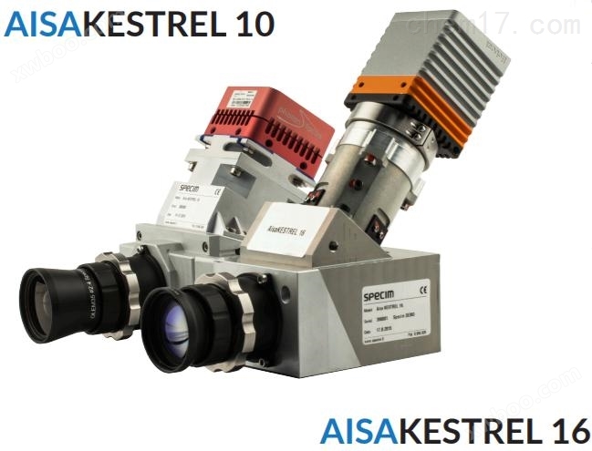
1.2 Hyperspectral System

- Truly research grade hyperspectral imaging technology, integrated with high-precision GNSS/IMU, without the need for a gimbal.
- Hyperspectral imaging lens: Built in push scan imaging.
- Resolution: 2040 or 640 pixels.
- High sensitivity and high signal-to-noise ratio.
- Spectral range 400-1000nmOr 600-1640nm.
- High precision GNSS/IMU sensor.
- Compatible with EcoDrone drone remote sensing, forming a complete drone hyperspectral remote sensing system.

The left image isHyperspectral calibration test flightRGB composite data,Trilateral routeUsed for sensor calibrationThe image on the right is a false color composite image. According to different research needs, 204 spectral images can be freely selected.
2 Technical indicators
2.1 Unmanned Aerial Vehicle System
drone platform | |
Symmetrical motor wheelbase |
1500mm |
payload |
7Kg |
Large load |
15Kg |
hover time |
15min (load 7Kg), 12min (load 15kg) |
Hovering accuracy (GPS mode) |
Vertical: ± 0.2m; Horizontal: ± 0.5m |
wind resistance |
Level 5 (8m/s, 28.8km/h) |
Rain resistance ability |
Work tasks can be performed in light rain weather, but not on rainy days |
Compatible with gimbal |
Zenmuse X3, Zenmuse X5 series, ZenmuseZT, ZenmuseZ3, GOPRO gimbal, etc |
power system | |
Power motor model |
DJI 12S |
Large rotational angular velocity |
Pitch axis: 300°/sHeading axis: 150°/s |
Large ascending speed |
5m/s |
Great descent speed |
3m/s |
Great level flight speed |
18m/s (windless environment) |
Large pitch angle |
25° |
Capable of withstanding high wind speeds |
10m/s(5 levels of wind can safely fly), can withstand instantly13m/s(Level 6 wind) |
High altitude flight |
≥5000m |
battery system | |
Battery Model |
LiPo6S |
battery capacity |
22000mAh |
battery energy |
501.6Wh |
Overall weight of battery |
2330g |
Charger function |
Dual 1400W |
flight control system | |
Flight control model |
PIXHAWK (open-source flight control) |
Remote control operating frequency |
840MHz |
communication range |
8km, Up to 15km |
Video output interface |
HDMI,SDI,USB |
Collaborative function |
Support multi machine interconnection |
2.2 Hyperspectral System
|
AISAKESTREL 10 |
AISAKESTREL 10 |
Camera specifications | ||
spectral range |
400-1000nm |
600-1640nm |
Spectral sampling rate |
1.75/3.5/7nm |
2.75/5.5nm |
F/# |
F/2.4 |
|
色散 |
<0.5 pixels |
<0.25/<0.5 pixels |
Polarization sensitivity |
<±2% |
|
Signal to noise ratio (peak) |
400-800 |
800 |
spatial resolution |
2040 pixels |
640 pixels |
frame rate |
Up to 170 or 100Hz |
100Hz |
integration time |
Adjustable within frame |
|
field of view |
40° |
|
Electromechanical shutter |
yes |
|
data interface |
CameraLink 12-bit |
CameraLink 14-bit |
data storage |
480GB SSD |
|
Total power of the system |
<41W |
<46W |
mechanical properties | ||
|
Dimensions (length x width x height) camera DPU GNSS/IMU |
127×180×225mm |
99×215×240mm |
Including front camera, 2.1kg |
Including front camera, 2.3kg |
|
165×154×101mm,1.6kg | ||
120×70×40mm,0.5kg | ||
Total weight of the system |
4.75kg |
5.0kg |
environmental characteristics | ||
Storage temperature |
-5……﹢50℃ |
|
Operating Temperature |
+5......+40 ℃, no condensation |
|
3 Professional Sensor Configuration
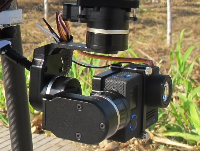
- Color lens (standard): 4k high-definition RGB lens, equipped with magnetic encoder gimbal, frame rate 30FPS (in case of high resolution 4K), 2.7k resolution frame rate 50FPS, image resolution 12MP (4000x3000 pixels), pitch angle-160~+160°, motion tracking accuracy ± 0.1 °, optical lens f/2.8, 35mm equivalent focal length 22.6mm, 82 degree HFOV, distortion free, mass 88g.

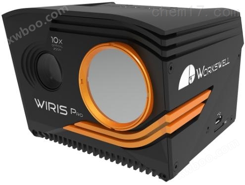
- Infrared thermal imaging (optional): Band 7.5-13.5μmResolution 640 × 512, sensitivity 30mK (0.03 ℃),1-14xDigital zoom, sensor calibrated and accompanied by calibration certificate, capable of real-time temperature measurement and analysis, temperature measurement range-25℃-+150℃; Built in color lens, resolution1600×1200Can simultaneously collect infrared thermal imaging videos and color videos or images online, withGPSInformation; Online measurement displays temperature range, center temperature, hot spot temperature, cold spot temperature, high peak and low peak temperatures, etc.

- Air quality monitoring module (optional): capable of measuring various air quality indicators including: air temperature and humidity CO2、PM2.5、PM10、VOC、 Formaldehyde concentration, light intensity, GPS coordinates, timestamp, etc; Equipped with GPS module, real-time recording and display of measurement data; Up to 150 kinds of sensors can be selected, and different sensors can be integrated according to the needs. Modular design allows for easy integration with other brands of drones.

4 application areas

Similar Product Recommend