-
E-mail
240137561@qq.com
-
Phone
15911168610
-
Address
No. 4 Baigezhuang Industrial Zone, Changping District, Beijing
Product Categories
Beijing Jingcheng Huatai Instrument Co., Ltd

Shanghai supplies GPS area measuring instruments
NegotiableUpdate on 03/24
- Model
- Nature of the Manufacturer
- Producers
- Product Category
- Place of Origin
Overview
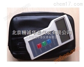
Brief description: The GPS area measuring instrument supplied by Shanghai is a high-precision GPS positioning system, an accurate area calculation method, a combination of slope area correction and PDA handheld computer system. Suitable for measuring the area of farmland, green spaces, forests, water bodies, mountain slopes, etc.
Product Details
Shanghai supplies GPS area measuring instrumentsFunctional features:
1) Adopting a 7-inch PDA and Android 4.1 system.
2) Automatic and manual measurement modes can be set, and after pausing, the automatic and manual modes can be switched at any time.
3) As the trajectory progresses, graphics can be automatically generated and the area and length can be calculated.
4) It can display the collection points and annotate them on the graph, allowing users to delete points with significant errors.
5) Equipped with a 4G SD card, users can import SD card data into a PC through the USB port for storage.
6) You can view the recorded graphics, area, length, and total price on the PDA.
7) In manual mode, each node collects data by taking the average value to reduce errors.
8) There are status reminders during measurement, displaying the current status, longitude, latitude, length, height, and area in real-time.
9) When the user sets the slope measurement, the slope area and total price are calculated by viewing the area.
10) It has in car functions and can watch movies and listen to music.
Shanghai supplies GPS area measuring instrumentsTechnical parameters:
1) Measurement data: area, perimeter, length, total price
2) Area measurement range: unlimited
3) Relative accuracy of area measurement: 5%<2 acres>, 3%<10 acres>, 2%<50 acres>, 1%<100 acres>
4) Distance measurement range: unlimited
5) Distance measurement accuracy: ± 2.5 meters
6) Usage conditions: Temperature -10 ℃~50 ℃, humidity 5%~95%
7) Record storage: unlimited (depending on SD card capacity).
It is a combination of high-precision GPS positioning system, accurate area calculation method, slope area correction, and PDA handheld computer system. Suitable for measuring the area of farmland, green spaces, forests, water bodies, mountain slopes, etc. After measurement, data such as area, perimeter, and total price can be obtained simultaneously, and the measured area graph and corresponding measurement data can be called up at any time for easy file storage and query. It is widely used in reaper area measurement, irregular plot measurement, agricultural machinery trans regional operation, rural land ownership confirmation, grassland ownership confirmation registration, water mudflat breeding, farmland area measurement, agricultural insurance survey and loss assessment.
GPS area measuring instrument is a convenient measuring tool for agricultural, forestry, water conservancy, soil management and other departments, as well as for manual operation fees of harvesters.
Similar Product Recommend