-
E-mail
3345036360@qq.com
-
Phone
13824116480
-
Address
Baiteng 1st Road, Doumen District, Zhuhai City, Guangdong Province
Product Categories
- Soil fertilizer nutrient rapid testing instrument for the entire project
- soil tester
- Soil hardness tester
- Soil tension meter
- Soil compaction tester
- Soil nutrient rapid analyzer
- Portable agricultural environment detector
- Soil Water Potential Temperature Rapid Measuring Instrument
- Soil moisture analyzer
Zhuhai Chiyu Huachen Technology Co., Ltd
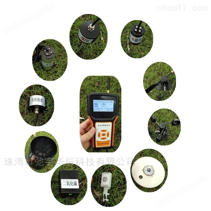
Handheld agricultural environmental meteorological monitoring instrument
NegotiableUpdate on 01/22
- Model
- Nature of the Manufacturer
- Producers
- Product Category
- Place of Origin
Overview
Model: CYHC-SC13 $r $n Handheld Agricultural Environmental Meteorological Monitor is an instrument developed by our company in response to market demand, which can simultaneously detect one or more environmental meteorological indicators. It can monitor soil moisture, soil temperature, soil salinity, soil pH, air temperature and humidity, carbon dioxide, light intensity, photosynthetically active radiation, wind speed and direction, rainfall and other indicators. This instrument is compact and portable, equipped with a portable bag for easy field monitoring. It is versatile and greatly saves users' costs, improves work efficiency, and avoids the tedious work of carrying two or more instruments for field monitoring.
Product Details
Handheld agricultural environmental meteorological monitoring instrumentTechnical Specifications:
1.Measurement indicators: Install sensors according to requirements
2.Sensor parameters: see section14Item Sensor Parameter Table
3.Response time:≤2second
4.Record capacity: standard configurationSDCard storage data reaches3Ten thousand pieces.
5.Record time interval:5min-99Hour continuous adjustable
6.Working environment temperature:10℃~55℃
7.Working environment humidity:5%~98%
8.Sensor communication:RS485
9.Upper computer communication:USB1.1
10.Cable length:2m(Can be customized according to customer needs, with a length of up to1000rice)
11.Power supply: built-in7.4V2.8Ahlithium battery
12.External dimensions:140mm×120 mm×35 mm
13.Weight: ≤1kg
14.Sensor technical parameters:standard configurationAir temperature and humidity, carbon dioxide, light intensity, soil moisture, soil temperature, photosynthetically active radiation, wind speed, wind direction, rainfall, soil pH, soil salinity;Users can choose to match sensors according to their actual needs.
test parameters |
test scope |
resolution |
accuracy |
soil moisture |
0~100% |
0.1% |
±1% |
soil temperature |
-40~100℃ |
0.1℃ |
±0.2℃ |
air temperature |
-40~120℃ |
0.1℃ |
±0.2℃ |
air humidity |
0~100% |
0.1% |
±3% |
dew point |
-40~120℃ |
0.1℃ |
±0.4℃ |
illuminance |
0~200000Lux |
1Lux |
±5% |
carbon dioxide |
0~5000ppm |
1ppm |
±3% |
dew point |
-40~120℃ |
0.1℃ |
±0.4℃ |
Photosynthetically active radiation |
0~2700µmolm-2s-1 |
1µmolm-2s-1 |
±1µmolm-2s-1 |
wind direction |
0~359° |
1° |
±1° |
wind speed |
0~65m/s |
0.1m/s |
±0.1m/s |
total radiation |
0~2000w/m |
1w/m |
7~14μV/w·m-2 |
precipitation |
0~4mm/min |
0.1mm/min |
±0.1mm/min |
PH |
1.0~14.0PH |
0.1PH |
±0.5 |
Soil salinity |
0~19.99ms/cm |
0.01ms/cm |
±2% |
soil compaction |
0~100kg |
0.1kg |
±0.5%F.S |
Other sensors that can be added: atmospheric pressure, radiation, direct radiation, ultraviolet radiation, evaporationPM2.5Sensors.
Handheld agricultural environmental meteorological monitoring instrumentFeatures:
1Full Chinese operating interface, large screen dot matrix LCD display, compact and easy to carry.
2Chinese LCD display, capable of displaying measurement data, battery level, current date, storage capacity, and quantity of stored data. currentGPSLocation, voice broadcast, alarm function, etc. are optional features.
3One click switching, can be manually recorded or set the sampling interval at any time without the computer, automatically records data and stores it.
4It can be used for both AC and DC, and can be used to measure and collect data in the field at any time, as well as to store recording locations for a long time.
5TheGPSPositioning function, automatic data collection, real-time on-site display of geographic coordinates (latitude and longitude information) of the location, and saving (optional).
7TheGPRSWireless transmission function, the measured data can be sent to the server in real time with one click or set the data transmission interval, and can be viewed and downloaded from anywhere as long as there is internet access (optional).
8The4GSDCard storage, with a storage capacity of up to3Ten thousand pieces; passSDExport data from the card toPCEnd.
9、 You can view data on the host or import it into the computer for viewing.
10It has power-off data protection function, and the data saved in the host is not lost.
11Function of upper computer software: Display each sensor parameter and process curve trend, large value, small value, average value, amplification, reduction, etc; Each type of sensor measurement data has been obtainedEXCELFormat saving, data reports and curve graphs can be viewed in selected time periods and printed through a computer. Curve coordinates can be moved and historical data analysis can be clearly set.
12Cloud platform management function: Customers can view historical and real-time data and curve graphs through any internet enabled computer or install them on any Android phoneAPPNo matter where you are, as long as there is a network, you can view real-time data;
Display sensor parameters and process curve trends, large values, small values, average values, amplification, reduction, etc. The data within the management platform can be downloaded, analyzed, and printed, and the data can be accessed throughGPRSUpload to the cloud platform, and the uploaded data can be saved for a long time; The sensor parameters can be set with safety conditions, and if they exceed the safety conditions, they will automatically sound an alarm and perform warning analysis; Software can be upgraded online(optional).
13Scalable sensor types and quantities, can be connected32One; The host can connect different types of sensors through a hub without affecting each other's accuracy.


